A map series of seafloor geomorphology, extractive industry, and ocean governance
Caroline Williams · May 4, 2026
Introduction
The seafloor is the least mapped surface on Earth.
It has mountain ranges and sediment plains, trenches and ridges — a geography as varied as anything on land, and far less understood. This map series traces how physical geography, industrial history, and legal frameworks have shaped each other over time.
The first map describes the seafloor itself: its shape, its structure, the geomorphic features that define it. The second traces the extractive industries that have followed those features for centuries. The third maps the legal frameworks that try to draw boundaries around what lies beneath.
Seafloor Geomorphology
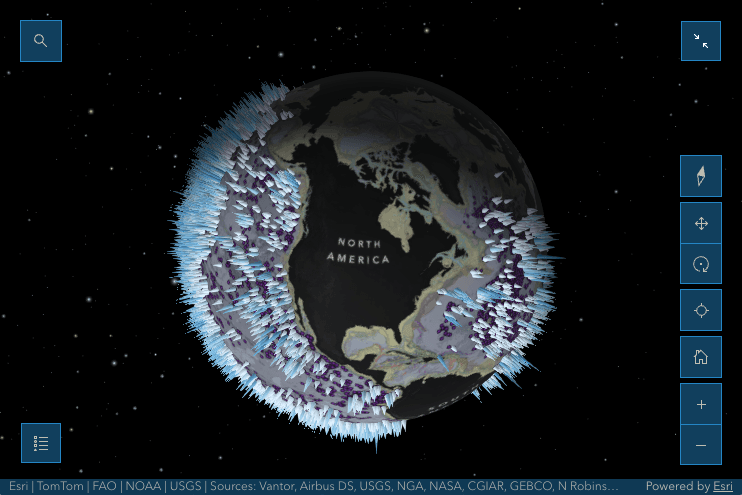
What is Seafloor Geomorphology?
Geomorphology is the study of landforms — the physical shapes and features that make up a surface. Seafloor geomorphology applies that same lens to the ocean floor: the mountains, valleys, plains, and ridges that lie beneath the water. Most people picture the ocean bottom as flat and featureless. It is anything but. The seafloor is one of the most varied and dramatic landscapes on Earth, shaped by the same geological forces that build mountains and carve valleys on land — just hidden from view beneath miles of water.
Seamounts and Canyons: Features of the Deep
Seamounts are underwater mountains, typically formed by volcanic activity. They rise from the seafloor but never breach the surface — though some, like Mauna Kea in Hawaii, are so tall that measured from their base on the ocean floor they surpass Mount Everest in height. Seamounts are not rare: there are estimated to be over 100,000 of them globally, and they are hotspots of marine biodiversity, providing hard surfaces for coral and sponge communities to anchor to in an otherwise soft-sediment world.
Submarine canyons are equally dramatic — steep, V-shaped valleys cut into the continental shelf and slope, often by ancient rivers or sediment flows. They act as highways for sediment moving from shallow coastal waters into the deep ocean, and like seamounts, they concentrate marine life.
Why It Matters: How Humans Use the Seafloor
Understanding the shape of the seafloor is not just a scientific exercise. It has direct practical consequences. Commercial fishing fleets target seamounts and canyon edges because that is where fish aggregate. Submarine communications cables — which carry over 95% of global internet traffic — are routed around and between these features to avoid damage. Navigation, particularly for submarines and deep-sea vessels, depends on accurate bathymetric charts of the seafloor's shape. And increasingly, the geomorphology of the seafloor is shaping decisions about where to mine, where to protect, and where to draw legal boundaries — the questions Maps 2 and 3 take up directly.
Map 1 Legend
Seamount height ranges from < 100 m to > 6,593 m. Source: World Seafloor Geomorphology.
Linear & Point Features
- Seamounts
- Guyots
- Canyons
- Bridges
- Sills
- Glacial troughs
- Shelf valleys
- Rift valleys
- Troughs
- Ridges
- Spreading ridges
- Terraces
- Escarpment
Basins
- Basins perched on the shelf
- Basins perched on the slope
- Large basins of seas and oceans
- Major ocean basins
- Small basins of seas and oceans
Broad Features
- Fans
- Trenches
- Rises
- Plateaus
- Hadal Zone
Geomorphic Zones
- Shelf
- Slope
- Abyss
- Hadal
Terrain Class
- Abyssal Mountains
- Abyssal Hills
- Abyssal Plains
- Shelf High
- Shelf Medium
- Shelf Low
Extractive Ocean Industries
The Seafloor as Infrastructure
Human use of the deep seafloor has expanded steadily from the mid-nineteenth century onward, driven by demand for energy, minerals, and global connectivity. Each wave of technological capability unlocked a new depth, a new resource, a new industrial footprint — and each one encountered the seafloor's geomorphology as both a constraint and a guide. The cable routes, drilling platforms, and mining lease zones that appear on this map are not random: they follow the contours of the landscape beneath them.
1850s–1900s: Laying Cable in the Dark
The first transoceanic telegraph cables crossed the Atlantic with minimal bathymetric data to guide them. Route planners worked largely blind, and early cables failed repeatedly — cut by anchors, crushed by pressure, or broken at canyon edges that no one had yet mapped. The effort nonetheless succeeded, and a template for global undersea infrastructure was established that would shape every subsequent wave of ocean industry.
1920s–1950s: Seeing the Seafloor for the First Time
Echo sounding enabled systematic seafloor mapping for the first time, and what it revealed transformed oceanography. The Mid-Ocean Ridge — the planet's longest mountain chain — had been invisible until then. Simultaneously, offshore oil and gas exploration began pushing onto the continental shelf, following the geology of shallow sedimentary basins toward deeper water.
1960s–1970s: Deeper, Further, Riskier
Offshore drilling expanded onto the continental slope, where submarine canyon systems created both engineering challenges and environmental risk. Unstable sediments and unpredictable terrain made well placement difficult and spill response harder. The first major subsea pipeline networks took shape during this period, threading carefully between geologic hazards that were only partially understood.
1980s–1990s: The Cable Revolution
Fiber optic cables replaced aging copper telegraph networks, and transoceanic cable infrastructure scaled rapidly across abyssal plains — the smoothest, most predictable terrain available. Modern cable routing reflects lessons learned from a century of failures: cables avoid canyon systems wherever possible, route around seamount flanks, and cluster in corridors where the seafloor is stable and depths are well-characterized.
2000s–Present: The Mining Frontier
Deep-sea mining exploration expanded onto seamount flanks and polymetallic nodule fields across the abyssal plains. The industry remains in a pre-commercial phase, but exploration licenses now cover millions of square kilometers of the international seabed. At the same time, the fiber optic cables laid in the 1990s have become critical global infrastructure — carrying over 95% of international data traffic — and their vulnerability to submarine canyon activity is a recognized geopolitical risk.
Where We Are Now
The industrial footprint on this map is the cumulative result of 170 years of expansion into a landscape that was, at the start, almost entirely unknown. What is striking is not just how far that footprint has reached — it is how consistently it has followed the seafloor's physical geography, even when that geography was poorly understood. The pattern holds from the first telegraph cables to the newest mining lease zones: industry has always moved faster than the maps that should have guided it. Map 3 asks what governance has managed to build in the space between.
Ocean Governance
Drawing Lines Over Invisible Space
Governing the ocean requires drawing boundaries over a space that is largely invisible, incompletely mapped, and shared by no single nation. The frameworks layered on this map — Exclusive Economic Zones, Marine Protected Areas, and the landmark 2023 High Seas Treaty — represent more than a century of international negotiation over a simple question: who has the right to use the ocean, and who bears responsibility for protecting it?
1945: The Claim That Changed Everything
The Truman Proclamation unilaterally asserted U.S. jurisdiction over continental shelf resources, triggering a cascade of similar claims by coastal states worldwide. It marked the beginning of the end of the ocean as a global commons — at least in the shallows — and set the political context in which all subsequent law-of-the-sea negotiations would unfold.
1958: The First Frameworks
The first UN Conference on the Law of the Sea produced the Geneva Conventions, establishing early frameworks for the territorial sea and continental shelf. The conventions reflected the technology and political economy of the postwar period — written largely for fisheries and offshore oil, before the scale of deep-sea mineral resources or the global cable network were understood.
1982: UNCLOS and the Architecture of Modern Ocean Law
The adoption of UNCLOS — the United Nations Convention on the Law of the Sea — remains the foundational moment in modern ocean governance. It established Exclusive Economic Zones extending 200 nautical miles from coastlines, defined continental shelf rights, and created a framework for the high seas and the Area beyond national jurisdiction. Critically, it designated the deep seabed as the “common heritage of mankind” — a political commitment whose practical meaning has been debated ever since.
1994: The ISA and the Mining Question
UNCLOS entered into force, and the International Seabed Authority was established to regulate deep-sea mining in areas beyond national jurisdiction. The ISA has since issued exploration licenses covering large swaths of the Pacific, Atlantic, and Indian Ocean abyssal plains — while simultaneously being asked to develop environmental regulations for an industry whose full ecological impacts remain poorly understood.
2000s–2010s: MPAs and the Protection Gap
MPA designation accelerated globally during this period, with seamounts and submarine canyon systems increasingly recognized as priority targets for protection. The ecological rationale was clear: these features concentrate biodiversity and are disproportionately vulnerable to bottom trawling and extractive industry. But MPA coverage of the high seas remained sparse, and enforcement remained difficult.
2023: The High Seas Treaty
The BBNJ Agreement was formally adopted by UN member states on June 19, 2023, after nearly two decades of negotiation — the conclusion of five intergovernmental conference sessions interrupted by COVID and repeatedly stalled over questions of benefit-sharing and the freedom of the seas. Adoption meant the text was agreed, but the treaty had no legal force yet. It opened for signature in September 2023, beginning the ratification process.
2026: Into Force
On January 17, 2026, the BBNJ Agreement entered into force — becoming binding international law after reaching the threshold of 60 ratifications. It is now the first legally binding framework specifically for protecting biodiversity in areas beyond national jurisdiction, covering nearly half of Earth's surface. The first Conference of the Parties must convene within a year of entry into force, meaning the hard work of implementation — establishing MPAs on the high seas, setting environmental impact assessment requirements, and operationalizing benefit-sharing — is just beginning. The story is not finished; it is newly started.
Where We Are Now
A century of ocean law has produced frameworks of genuine consequence — UNCLOS, the ISA, the BBNJ Agreement — and yet the gap between what those frameworks promise and what they deliver remains wide. The high seas are newly protected on paper. The mining code is still unfinished. MPA coverage of the deep ocean is uneven and enforcement is thin. What this map shows, ultimately, is that governance has followed the same pattern as the industries it was meant to regulate: always expanding, never quite catching up to the landscape it is trying to manage.
Conclusion
These maps are incomplete. The seafloor is largely unmapped and still unknown: some areas surveyed in detail, vast stretches never surveyed at all, and much of the data that exists held privately. What appears here is a picture built from the best available evidence, not a definitive account.
And yet the stakes of that incompleteness are growing. Decisions about the deep ocean are being made now, about extraction, about protection, about who has the right to decide, and they are being made, in many cases, faster than the science that should inform them.
The question these maps leave open is not whether humans will continue to engage with the seafloor. They will. That gap between what we know and what we are deciding is, perhaps, the most important thing these maps have to say.
INFO-669-01: Independent Study
Developed as a self-directed research project examining the intersection of policy, technology, and earth science in modern ocean mapping.